You are here:
Find out the latest on the Digital Twin Victoria program.
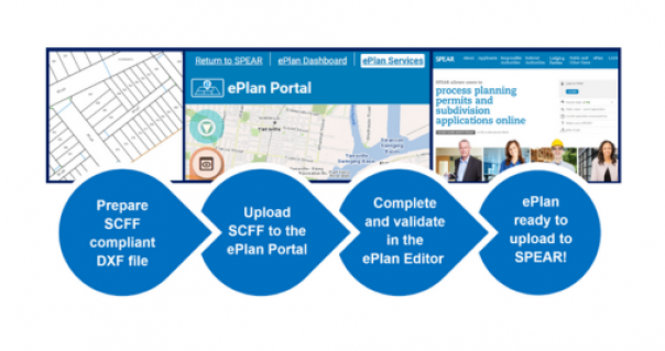
Victoria is taking the next step towards a fully digital land registry with notification of a phased mandate for digital submission of plan data.
The Victorian Government has released the eComply Framework that defines specifications for BIM-enabled digital compliance assessment practices.
The Ararat Digital Twin Spotlight Project marked a milestone with the inauguration of the Fab Lab at the Ararat Jobs and Technology Precinct.
Digital Twin Victoria (DTV) is introducing next-generation DTV Portals, unlocking more powerful self-service features for government.
Digital Twin Victoria and DataVic bring you interactive previews of spatial data straight from the DTV platform when you explore DataVic.
New Vicmap 3D Buildings datasets released through Digital Twin Victoria to help plan for a future-ready Victoria.
Smart sensor technology set to be rolled out in regional Victoria as part of Digital Twin Victoria data visualisation and agricultural insights project.
Page last updated: 15/05/24