A 10-year strategy for Victoria’s cadastral system
Advancing Victoria’s official digital record and map of property boundaries.
On this page:
The strategy
The cadastre is Victoria’s official digital record and map of property boundaries for the state’s 3.6 million land parcels.
The cadastre helps us build liveable, sustainable, safe and resilient communities. It supports emergency service preparedness, response, and recovery, and empowers businesses and individuals through access to land information.
With Victoria’s population set to grow from around 6.5 million today to over 10 million by 2051, the state is experiencing a period of accelerated property development, land subdivision construction and urban renewal.
The Victorian Government has invested $45 million in Digital Cadastre Modernisation to accurately display Victorian property boundaries in digital format. This has presented further opportunities to drive transformation across Victoria’s cadastral system and realise even greater efficiencies and cost savings.
The 10-year Strategy for Advancing Victoria’s Cadastral System outlines the vision and approach for a future-ready land administration system.
Vision: a fully digital, highly automated and spatially accurate cadastral system that enables creating, managing and visualising the location and spatial extent of all known interests in Victorian land.
The 10-Year Strategy for Advancing Victoria’s Cadastral System outlines how we will advance the current system over the next ten years:
Articulate a clear, shared vision for a future-state cadastral system.
Outline our approach to aligning and delivering a range of existing and emergent digital transformation initiatives, staged across ten years.
Establish guiding principles that set standards for change, growth, design and implementation.
Articulate detailed Horizon 1 goals to be achieved by the end of 2024, with high-level focus areas to be achieved in future horizons.
Identify the outcomes and benefits from delivering the strategy.
Stakeholder engagement
In preparing the strategy, we have worked closely with a broad range of stakeholders who interact with our cadastral system. The strategy harnesses their views about what a future-ready cadastral system must deliver to government, industry and community sectors.
Timeline and milestones
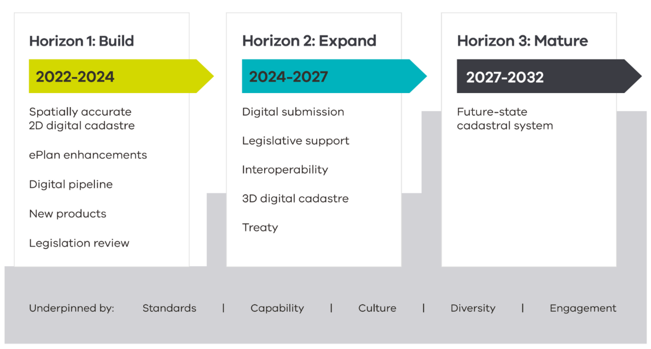
The 10-year strategy will be implemented over three horizons, with each horizon containing milestones to make our cadastral system future-ready by 2032.
The strategy will be implemented over 3 horizons.
Horizon 1: Build 2022-2024
Spatially accurate 2D digital cadastre
ePlan enhancements
Digital pipeline
New products Legislation review
Horizon 2: Expand 2024-2027
Digital submission
Legislative support
Interoperability
3D digital cadastre
Treaty
Horizon 3: Mature 2027-2032
Future-state cadastral system
Horizon 1:
Establish the building blocks required for future transformation. This includes the finalisation of the Digital Cadastre Modernisation project, enhancements to ePlan to enable digital lodgement of survey plan data and the establishment of a pathway to mandatory submission for all digital plan and survey plan data.
Horizons 2 and 3:
Expand and mature these building blocks, working towards the 10-year vision for Victoria’s cadastral system.
The three horizons are underpinned by standards, capability, culture, diversity and engagement.
Projects and initiatives
The following projects and initiatives are key areas of investment in Victoria’s cadastral system that the Department of Transport has committed to under this strategy.
The Digital Cadastre Modernisation (DCM) is a $45 million project that is upgrading Victoria’s official digital record and cadastral map of property boundaries for the state’s 3.3 million land parcels.
Now complete, it will reduce financial costs and boost productivity for government, private sector and everyone involved in the planning stage of large infrastructure projects.
ePlan provides the enabling technology and infrastructure to support the encoding and exchange of digital cadastral information. The benefits of ePlan include the re-use and pre-population of cadastral information; streamlined validation; and minimised duplication of effort, requisitions and plan amendments.
ePlan is being progressively implemented through the Single CAD Format File (SCFF) to increase the efficiency of creating and submitting digital information. Our future-state system will support 3D cadastral plans and surveys using a nationally consistent standard known as a 3D Cadastral Survey Data Model (3D CSDM).
Several initiatives are underway to transform our services to fully digital ways of working. This includes a simpler and more seamless process for the submission and processing of planning and surveying applications, referrals and lodgments.
For example, SPEAR already allows plan and survey documents to be submitted electronically. The next step is to enable plan and survey information to be submitted as digital data.
Faster subdivision registration
This initiative will develop the enabling technology and infrastructure to support the digital examination and validation of subdivisions. It is designed to enhance the integrity of the cadastre, deliver more consistent and efficient processes and decisions, and achieve faster registration times. When complete in June 2024, systems and processes will be in place to enable mandating the submission of digital cadastral data.
eComply
eComply is a 3D building assessment framework that uses digital compliance tools to streamline the planning approvals process for residential housing. The solution will enable architects, builders and developers to pre-check their designs against building codes, leading to more consistent compliance checking and faster approval times.
The Digital Twin Victoria (DTV) program is a $37.4 million investment in digital twin technology, geospatial data and spatial innovation over four years. Faster subdivision and eComply are two projects being delivered through this program.
Vicmap is Victoria’s state-wide portfolio of authoritative spatial data products that provide the foundation for Victoria’s primary mapping and spatial information systems. Developments in Vicmap will continue to enhance and inform our cadastral system.
Several initiatives are being implemented to improve the accuracy and reliability of the core datasets, the way the datasets are maintained, and how users experience the data and services.
We are also working on publishing a new Vicmap product known as Vicmap Survey, which will provide licensed surveyors with a digital record of cadastral boundaries and state borders, as well as an indication of survey differences and cadastral re-establishment issues.
In every case, we are seeking to adopt cutting-edge machine learning technologies and automation to help streamline, reduce costs and speed up how we keep our data accurate and up to date.
The Surveyors Registration Board of Victoria (SRBV) is responsible for the registration and licensing of cadastral surveyors. Victoria needs more licensed surveyors to meet growing demands from the construction and land development sectors.
Following a review of the licensing process, SRBV is working on streamlining the process for registering licensed surveyors. This work is progressing in collaboration with the Council of Reciprocating Surveyors Board of Australia and New Zealand.
Systems index
The Land and Survey Spatial Information (LASSI) mapping service is provided by Land Services Victoria to search property details. The LASSI mapping service provides a suite of four applications that can be used to find information about a parcel of land or property online and geographic place names throughout Victoria.
LANDATA provides access to property information held in the Victorian Register of Titles. You can use LANDATA to search for land titles, mortgage details, surveys, land valuations, property sales, property and planning certificates.
The Surveying and Planning through Electronic Applications and Referrals (SPEAR) system allows subdivision planning permits, certification applications and other land administration dealings to be compiled, lodged, managed, referred, approved and tracked online. Complete end-to-end workflows are built into SPEAR allowing applications to be lodged online with Land Services Victoria for registration.
The Victorian Online Titles System (VOTS) is the digital platform and database used in Victoria to manage and record information related to land ownership and associated interests.
ePlan is a digital data file that contains cadastral surveying and administrative information related to a plan produced by a licensed surveyor.