Use ground surface information to analyse terrain and make land assessments in Victoria.
On this page:
Overview
Vicmap Elevation and Depth products are derived from remote sensing data sources. Early Vicmap Elevation products were mapped by hand from stereographic aerial photography and exclusively represented the land surface and land surface features. Today, Vicmap uses technologies like LiDAR, radar and echo sounding to expand its representation of elevation and depth features.
In addition to the traditional land surface, Vicmap Elevation and Depth also include above-ground features (natural and built) as well as underwater or topographic depth features (bathymetry). The representation of the elevation and depth features conforms to the ANZLIC Foundational Spatial Data Framework.
Within the Vicmap Elevation and Depth product family, these datasets are categorised by how they are represented: Elevation Surfaces, Elevation Point Clouds and Elevation Features.
Elevation Surfaces
Vicmap Elevation Surface products comprise of data that are modelled to represent continuous height or elevation surfaces in a gridded data format.
The ground surface, known as a Digital Elevation Model (DEM), has traditionally been the elevation surface of most use. However, above-ground and below-water (bathymetry) surfaces have increasingly become important and these types of surface products are planned for future release.
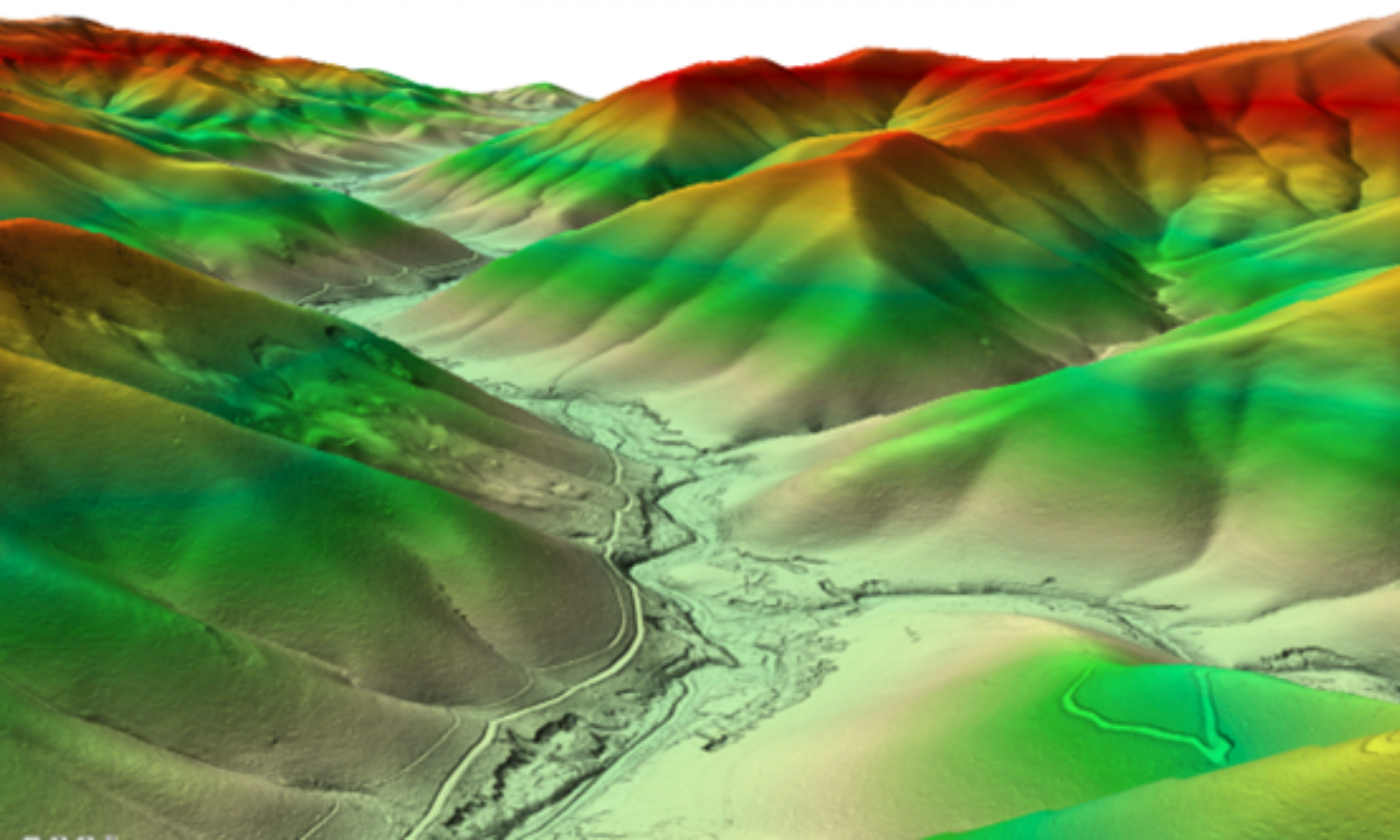
The Buckland River Valley DEM data set from the Vicmap Elevation – LiDAR DEMs collection shown as a hill shaded surface in 3D perspective.
Explore available Vicmap Elevation Surface products:
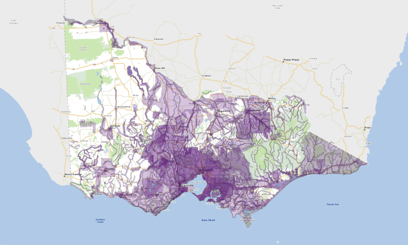
The Vicmap Elevation LiDAR DEMs Collection is a compilation of ground surface models derived from Aerial LiDAR surveys undertaken through the Coordinated Imagery Program (CIP) since 2007. The collection represents the most comprehensive and extensive archive of LiDAR-derived DEMs for the State of Victoria.
The LiDAR DEMs are closely associated with the Vicmap Elevation – LiDAR Points Collection, with each DEM being sourced from a related point cloud data set. By virtue of its collection history, datasets within the collection vary in currency, as well as resolution and accuracy. The collection currently covers approximately 60% of the state's land area and achieves coverage of over 99% of the state's populated areas.
Source
Aerial LiDAR survey
Resolution
Ranging from 50 cm to 5 m
Currency
Ranging from 2007 to present
Vertical Accuracy
Ranging from +/-50 cm RMSE to +/-10 cm RMSE
Horizontal Datum
Ranging from GDA94 to GDA2020
Vertical Datum
AHD
Format
Ranging from ESRI Ascii GRID to Cloud Optimised GeoTIFF
Coordinates
Ranging from GDA94 zone 54 and 55 to GDA2020 zone 54 and 55
Coverage
60% of Victoria
Learn more about the Vicmap Elevation – LiDAR DEMs Collection
In exceptional cases, some project specific Vicmap LiDAR DEMs datasets are available under Creative Commons by Attribution – Non Commercial 4.0 Australia license (CC BY-NC 4.0). These can be discovered and downloaded directly from the ELVIS platform provided by Geoscience Australia.
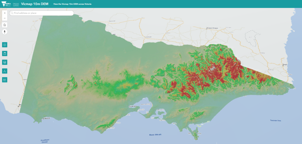
The Vicmap 10m DEM is a statewide 10 m resolution DEM constructed primarily from early Vicmap Elevation Vector products and updated with more recent DEMs from the Vicmap Elevation – LiDAR DEMs Collection. As such, Vicmap 10m DEM comprises data of various resolutions, accuracies and epochs, with respective horizontal and vertical accuracy rated at 12.5 m and 5 m RMSE or better.
Vicmap 10 m DEM is currently the only Vicmap DEM that is hydrologically enforced to correctly define natural surface drainage and hydrological flow.
Source
Primarily Vicmap 10m – 20m Contours and Relief.
Secondarily updated with DEM datasets from the Vicmap LiDAR DEMs Collection to improve accuracy in localised areas.
Vicmap Elevation Point Cloud products primarily comprise LiDAR-derived mass 3D point data sets. LiDAR point clouds are the raw source of most Vicmap Elevation products. Although closely associated with gridded surface products (such as Digital Elevation Models and Digital Surface Models), point clouds are technically vector products by virtue of their representation as point features.
Elevation point clouds inherently have both position (X,Y) and height (Z) attributes, but depending on their source may also carry an array of additional attributes.
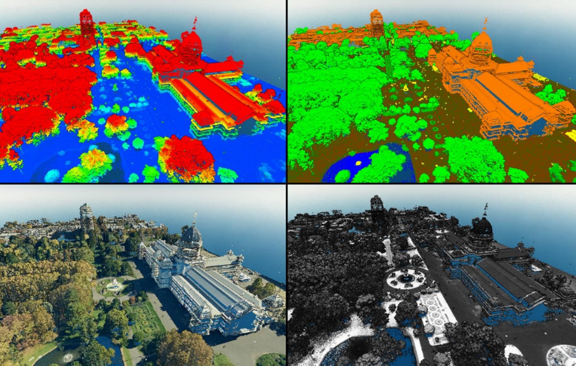
This LiDAR derived point cloud carries elevation attributes (top left), land cover classification (top right), true colour RGB values (bottom left) and laser return intensity values (bottom right).
Explore available Vicmap Elevation Point Cloud Products
Vicmap LiDAR Points Collection is a compilation of point cloud data sets captured from LiDAR surveys undertaken by the Coordinated Imagery Program since 2007. The collection represents the most comprehensive and extensive archive of LiDAR data available for the State of Victoria.
The LiDAR Points are closely associated with the Vicmap Elevation – LiDAR DEMs Collection, as each point cloud data set is paired with a derived DEM data set. By virtue of its collection history, datasets within the collection vary in currency, as well as point density and accuracy. The collection currently covers approximately 60% of the state's land area and achieves coverage of over 99% of the state's populated areas.
Source
Aerial LiDAR survey
Point Density
Ranging from 2 pts/m2 to 24 pts/m2
Currency
Ranging from 2007 to present
Vertical Accuracy
Ranging from +/-50 cm RMSE to +/-10 cm RMSE
Horizontal Datum
Ranging from GDA94 to GDA2020
Vertical Datum
Ellipsoidal and AHD
Format
Ranging from LAS to LAZ
Coordinates
Ranging from GDA94 zone 54 and 55 to GDA2020 zone 54 and 55
Coverage
60% of Victoria
Learn more about the Vicmap Elevation – LiDAR Points Collection
In exceptional cases, some project-specific Vicmap LiDAR Points datasets are available under Creative Commons by Attribution – Non-Commercial 4.0 Australia license (CC BY-NC 4.0). These can be discovered and downloaded directly from the ELVIS platform provided by Geoscience Australia.
Elevation Features
Vicmap Elevation features comprise traditionally represented contour, spot height and landform features mapped from stereographic imagery. Elevation features are vector data sets that represent different types of ground surface features as points, lines and polygons.
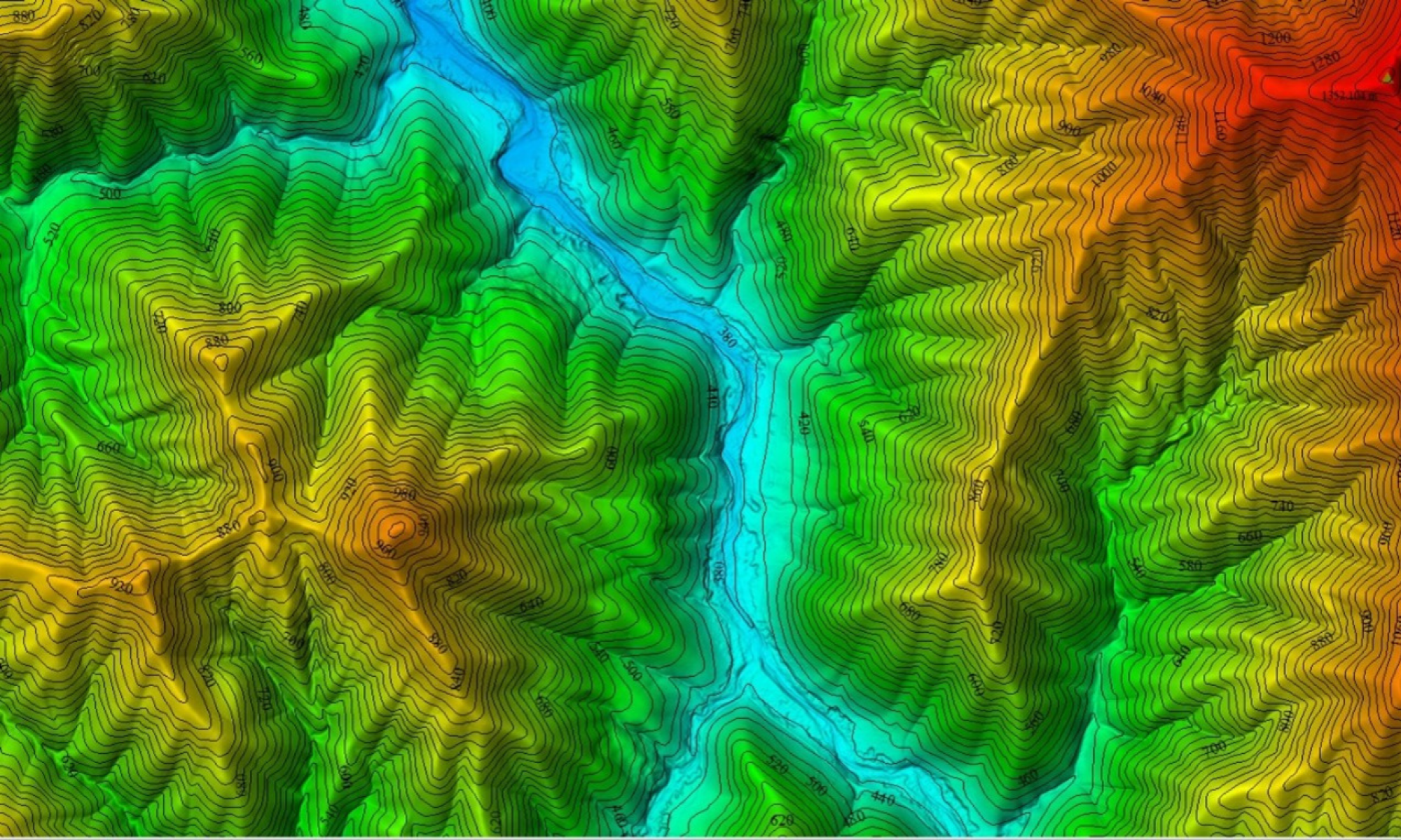
Buckland River Valley, North-East Victoria. Vicmap Elevation 10 m - 20 m Contours displayed over Buckland River Valley DEM data set from the Vicmap Elevation – LiDAR DEMs collection.
Explore available Vicmap Elevation Feature products
Vicmap 10m – 20m Contours and Relief represents Victoria’s elevations in the form of contours, spot heights and surface features including cliffs, embankments, and rock outcrops.
This product can be used in a variety of applications including emergency services, natural resource management, planning and development, and digital map publication.
Source
Vicmap Topographic Maps (stereo photogrammetry)
Scale of capture
1:25,000
Currency
1960s – 1990s
Special features
10 m contour intervals (20 m in steep terrain), spot heights, surface features (e.g. cliffs and levee banks).
Vertical accuracy
+/-5 m for 10 m contours and +/-10 m for 20 m contours
Horizontal datum
GDA94
Vertical datum
AHD
Format
Various vectors
Coordinates
VicGrid
Coverage
Statewide
Learnmore about Vicmap Elevation – 10m-20m Contours and Relief
AccessVicmap Elevation – 10m-20m Contours and Relief
Vicmap Elevation – 10m – 20m Contours and Relief are Open data and available under a Creative Commons license. Vicmap Elevation – 10m – 20m contours can be accessed on Data.Vic.
Vicmap Elevation – 1m-5m Contours and Relief provide a contour overlay of the Melbourne metropolitan area.
Sourced from the former Melbourne Metropolitan Board of Works surveys from 1970 to 1980, this dataset has traditionally been used for feature and contour surveys, planning applications and broad-scale volume estimations.
Source
Melbourne Water (stereo photogrammetry)
Scale of Capture
1:5,000-1:10,000
Currency
1970s to 1980s
Special Features
Mostly 1m intervals; some locations have only 2m or 5m contours.
Vertical Accuracy
+/-50 cm for 1m contours and +/-2.5 m for 5m contours
Horizontal Datum
GDA94
Vertical Datum
AHD
Format
Various Vector
Coordinates
VicGrid
Coverage
Melbourne Metropolitan Area
AccessVicmap Elevation – 1m-5m contours and relief Melbourne metro
Vicmap Elevation 1m-5m contours and relief Melbourne Metro data is Open data and available under a Creative Commons license. Vicmap Elevation 1m-5m contours and relief Melbourne Metro can be accessed on Data.Vic.